|
|
Antenna Structure Registration 1026468 |
 |
Registration Info | Registration Number: 1026468 |
| File Number: A1232432 |
| FAA Study: 97-AWP-1915-OE |
| FAA Issue Date: 08/14/1997 |
| Status: Constructed |
| Date Constructed: 01/01/1980 |
| NEPA: N |
Structure Info
| Structure Type: TOWER |
| Structure Coordinates: 33-0-32.0 N 116-58-19.0 W (NAD 83) |
| Structure Coordinates: 33-00-31.8 N 116-58-15.9 W (Converted to NAD 27) |
| Structure Address: Woodson Mountain Near |
| Structure City: Poway, CA |
| Structure County: San Diego County |
| Painting & Lighting Info |
FAA Chapters: NONE |
Remarks: Removed expiration date from determination. Scenario 1./jjs/case#635066 |
| Elevation Info |
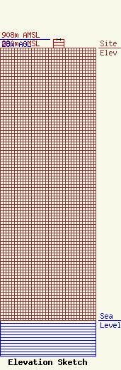
Site Elevation: 880 meters (2887 ft) |
| Height of Structure: 28 meters (92 feet) |
| Overall Height Above Ground: 28 meters (92 feet) |
| Overall Height Above Mean Sea Level: 908 meters (2979 feet) |
| Owner Info | Palomar Communications, Inc.
2230 Micro Place
Escondido, CA 92029
(760) 746-2120
palomarcomm@gmail.com |
| Contact Info | Palomar Communications, Inc.
2230 Micro Place
Escondido, CA 92029
Jon Cook
(760) 746-2120
palomarcomm@gmail.com |
