|
|
Antenna Structure Registration 1033923 |
 |
Registration Info | Registration Number: 1033923 |
| File Number: A0040231 |
| FAA Study: 79-ANW-258-OE |
| Status: Constructed |
| Date Constructed: 08/07/1980 |
| NEPA: N |
Structure Info
| Structure Type: TOWER |
| Structure Coordinates: 42-8-43.0 N 121-46-19.0 W (NAD 83) |
| Structure Coordinates: 42-08-43.5 N 121-46-15.0 W (Converted to NAD 27) |
| Structure Address: Miller Hill |
| Structure City: Klamath Falls, OR |
| Structure County: Klamath County |
| Painting & Lighting Info |
FAA Circular #: 70/7460-1F |
FAA Chapters: 3, 5 |
| Elevation Info |
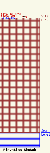
Site Elevation: 1400 meters (4593 ft) |
| Height of Structure: 18 meters (59 feet) |
| Overall Height Above Ground: 24.4 meters (80 feet) |
| Overall Height Above Mean Sea Level: 1424.4 meters (4673 feet) |
| Owner Info | PUTNAM, L R DBA = CASCADE TELECOM
333 SPRING ST
KLAMATH FALLS, OR 97601
(541) 883-3322
|
