|
|
Antenna Structure Registration 1202397 |
 |
Registration Info | Registration Number: 1202397 |
| File Number: A0934694 |
| FAA Study: 2014-AWP-9445-OE |
| FAA Issue Date: 01/09/2015 |
| Status: Constructed |
| Date Constructed: 12/17/1998 |
| NEPA: N |
Structure Info
| Structure Type: LTOWER |
| Structure Coordinates: 33-49-49.2 N 116-57-14.1 W (NAD 83) |
| Structure Coordinates: 33-49-49.1 N 116-57-11.0 W (Converted to NAD 27) |
| Structure Address: 40700 Soboba Road (8672) |
| Structure City: Banning, CA |
| Structure County: Riverside County |
| Painting & Lighting Info |
FAA Chapters: NONE |
Remarks: PRIOR STUDY 2013-AWP-7665-OE |
Remarks: Removed expiration date from determination. Scenario 1./jjs/case#635066 |
Remarks: PRIOR STUDY 2013-AWP-7665-OE |
Remarks: Removed expiration date from determination. Scenario 1./jjs/case#635066 |
| Elevation Info |
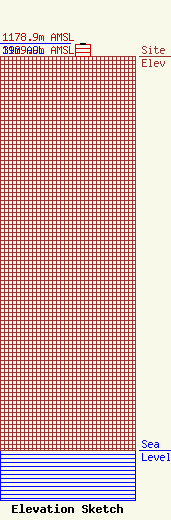
Site Elevation: 1139.9 meters (3740 ft) |
| Height of Structure: 36.6 meters (120 feet) |
| Overall Height Above Ground: 39 meters (128 feet) |
| Overall Height Above Mean Sea Level: 1178.9 meters (3868 feet) |
| Owner Info | American Towers LLC
10 Presidential Way
Woburn, MA 01801
(678) 564-3236
faa-fcc@americantower.com |
| Contact Info | American Towers, LLC.
10 Presidential Way
Woburn, MA 01801
Julie Kim
(678) 564-3236
faa-fcc@americantower.com |
