|
|
Antenna Structure Registration 1240386 |
 |
Registration Info | Registration Number: 1240386 |
| File Number: A1231887 |
| FAA Study: 2022-ANM-6507-OE |
| FAA Issue Date: 11/07/2022 |
| Status: Constructed |
| Date Constructed: 03/23/2004 |
| NEPA: N |
Structure Info
| Structure Type: LTOWER |
| Structure Coordinates: 37-3-49.2 N 113-34-27.9 W (NAD 83) |
| Structure Coordinates: 37-03-49.3 N 113-34-25.1 W (Converted to NAD 27) |
| Structure Address: Webb Hill Hillrise Dr. (210222) |
| Structure City: Saint George, UT |
| Structure County: Washington County |
| Painting & Lighting Info |
FAA Chapters: NONE |
Remarks: PRIOR STUDY 2015-ANM-2841-OE |
| Elevation Info |
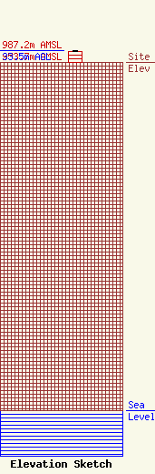
Site Elevation: 953.7 meters (3129 ft) |
| Height of Structure: 30.5 meters (100 feet) |
| Overall Height Above Ground: 33.5 meters (110 feet) |
| Overall Height Above Mean Sea Level: 987.2 meters (3239 feet) |
| Owner Info | American Towers LLC
10 Presidential Way
Woburn, MA 01801
(781) 926-4500
faa-fcc@americantower.com |
| Contact Info | American Towers LLC
10 Presidential Way
Woburn, MA 01801
(781) 926-4500
faa-fcc@americantower.com |
