|
|
Antenna Structure Registration 1317411 |
 |
Registration Info | Registration Number: 1317411 |
| File Number: A1341512 |
| FAA Study: 2020-ACE-4121-OE |
| FAA Issue Date: 07/13/2020 |
| Status: Constructed |
| Date Constructed: 01/29/2021 |
Structure Info
| Structure Type: LTOWER |
| Structure Coordinates: 36-40-56.1 N 93-10-49.2 W (NAD 83) |
| Structure Coordinates: 36-40-55.9 N 93-10-48.6 W (Converted to NAD 27) |
| Structure Address: Hines Road |
| Structure City: Kirbyville, MO |
| Structure County: Taney County |
| Painting & Lighting Info |
FAA Chapters: NONE |
Remarks: PRIOR STUDY 2019-ACE-4999-OE |
| Elevation Info |
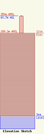
Site Elevation: 289.3 meters (949 ft) |
| Height of Structure: 59.4 meters (195 feet) |
| Overall Height Above Ground: 60.7 meters (199 feet) |
| Overall Height Above Mean Sea Level: 350 meters (1148 feet) |
| Owner Info | VB BTS, ll, LLC
22 W Atlantic Avenue
Delray Beach, FL 33444
(561) 406-4015
fcc-faa@verticalbridge.com |
| Contact Info | VB BTS, ll, LLC
22 W Atlantic Avenue
Delray Beach, FL 33444
Richard Hickey
(561) 406-4015
fcc-faa@verticalbridge.com |
