|
|
Antenna Structure Registration 1323158 |
 |
Registration Info | Registration Number: 1323158 |
| File Number: A1224350 |
| FAA Study: 2016-ASW-7307-OE |
| FAA Issue Date: 09/14/2016 |
| Status: Constructed |
| Date Constructed: 10/06/2022 |
Structure Info
| Structure Type: LTOWER |
| Structure Coordinates: 29-49-33.0 N 95-22-36.0 W (NAD 83) |
| Structure Coordinates: 29-49-32.2 N 95-22-35.2 W (Converted to NAD 27) |
| Structure Address: 7135 Fulton Street |
| Structure City: Houston, TX |
| Structure County: Harris County |
| Painting & Lighting Info |
FCC Paragraph(s): A1, H |
Remarks: Continue As Is OM&L = 24-HR MED-STROBES |
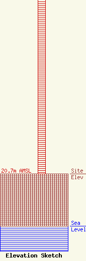
| Elevation Info |
Site Elevation: 20.7 meters (68 ft) |
| Height of Structure: 75.9 meters (249 feet) |
| Overall Height Above Ground: 75.9 meters (249 feet) |
| Overall Height Above Mean Sea Level: 96.6 meters (317 feet) |
| Owner Info | New Beginnings Fellowship Church
70 Neyland street
310841
Houston, TX 77022
(713) 261-1594
joedonalson@gmail.com |
| Contact Info | New Beginnings Fellowship Church
70 Neyland Street
310841
Houston, TX 77022
Joe Donalson
(713) 261-1594
joedonalson@gmail.com |
