|
|
Antenna Structure Registration 1064433 |
 |
Registration Info | Registration Number: 1064433 |
| File Number: A1095395 |
| FAA Study: 2006-AWP-880-OE |
| FAA Issue Date: 03/13/2006 |
| Status: Granted |
| Date Constructed: 04/12/1999 |
| NEPA: N |
Structure Info
| Structure Type: TOWER |
| Structure Coordinates: 37-57-29.8 N 121-16-58.6 W (NAD 83) |
| Structure Coordinates: 37-57-30.1 N 121-16-54.8 W (Converted to NAD 27) |
| Structure Address: 721 E. Lindsay Street |
| Structure City: Stockton, CA |
| Structure County: San Joaquin County |
| Painting & Lighting Info |
FAA Circular #: 70/7460-1K |
FAA Chapters: 3, 4, 5, 12 |
Remarks: PRIOR STUDY 1998-AWP-2582-OE |
| Elevation Info |
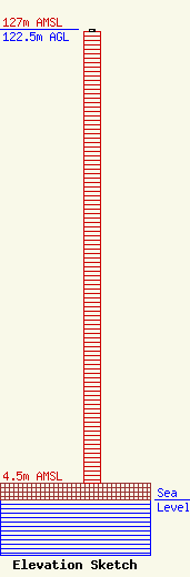
Site Elevation: 4.5 meters (15 ft) |
| Height of Structure: 121.9 meters (400 feet) |
| Overall Height Above Ground: 122.5 meters (402 feet) |
| Overall Height Above Mean Sea Level: 127 meters (417 feet) |
| Owner Info | Bank of Stockton Trustee of the Ann Matlow Trust
1030
Aptos, CA 95001
(209) 888-8080
john@pavilioncommunications.com |
| Contact Info | Pavilion Communications, LLC
1030
Aptos, CA 95001
John La Rue
(209) 888-8080
john@pavilioncommunications.com |
