|
|
Antenna Structure Registration 1233377 |
 |
Registration Info | Registration Number: 1233377 |
| File Number: A0926003 |
| FAA Study: 2014-ASW-1973-OE |
| FAA Issue Date: 03/26/2014 |
| Status: Constructed |
| Date Constructed: 11/05/2014 |
| FAA EMI: N |
| NEPA: N |
Structure Info
| Structure Type: LTOWER |
| Structure Coordinates: 34-2-43.7 N 106-54-23.4 W (NAD 83) |
| Structure Coordinates: 34-02-43.5 N 106-54-21.3 W (Converted to NAD 27) |
| Structure Address: 834 U S Hwy 60 West (373214 / Socorro Nm) |
| Structure City: Socorro, NM |
| Structure County: Socorro County |
| Painting & Lighting Info |
FAA Circular #: 70/7460-1K |
FAA Chapters: 4, 8, 12 |
Remarks: PRIOR STUDY 2014-ASW-1847-OE CHAPTERS 4,8,12 (1K) ADD SPECIAL CONDITION FOR LIGHTING DEVIATION. |
Remarks: Unterminated determination at the request of the FCC./ad/case#2291370 |
Remarks: PRIOR STUDY 2014-ASW-1847-OE CHAPTERS 4,8,12 (1K) ADD SPECIAL CONDITION FOR LIGHTING DEVIATION. |
Remarks: Unterminated determination at the request of the FCC./ad/case#2291370 |
| Elevation Info |
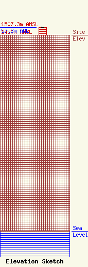
Site Elevation: 1450 meters (4757 ft) |
| Height of Structure: 56.4 meters (185 feet) |
| Overall Height Above Ground: 57.3 meters (188 feet) |
| Overall Height Above Mean Sea Level: 1507.3 meters (4945 feet) |
| Owner Info | Global Tower, LLC. through American Towers, LLC
10 Presidential Way
Woburn, MA 01801
(678) 564-3236
faa-fcc@americantower.com |
| Contact Info | American Towers, LLC.
10 Presidentail Way
Woburn, MA 01801
(678) 564-3236
faa-fcc@americantower.com |
