|
|
Antenna Structure Registration 1035328 |
 |
Registration Info | Registration Number: 1035328 |
| File Number: A1287688 |
| FAA Study: 97-ANM-1365-OE |
| FAA Issue Date: 11/05/1997 |
| Status: Constructed |
| Date Constructed: 01/01/1975 |
| FAA EMI: N |
| NEPA: N |
Structure Info
| Structure Type: TOWER |
| Structure Coordinates: 46-10-58.0 N 122-57-33.0 W (NAD 83) |
| Structure Coordinates: 46-10-58.6 N 122-57-28.6 W (Converted to NAD 27) |
| Structure Address: 996 Lone Oak Rd. |
| Structure City: Longview, WA |
| Structure County: Cowlitz County |
| Painting & Lighting Info |
FAA Circular #: 70/7460-1J |
FAA Chapters: 3, 4, 5, 13 |
Remarks: Removed expiration date from determination. Scenario 1./jjs/case#635066 |
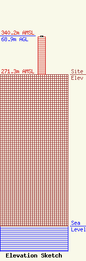
| Elevation Info |
Site Elevation: 271.3 meters (890 ft) |
| Height of Structure: 67.9 meters (223 feet) |
| Overall Height Above Ground: 68.9 meters (226 feet) |
| Overall Height Above Mean Sea Level: 340.2 meters (1116 feet) |
| Owner Info | TVT II, LLC
495 Tennessee Street, Suite #152
Memphis, TN 38103
(901) 277-4083
royal@towerventures.com |
| Contact Info | TVT II, LLC
495 Tennessee Street, Suite #152
Memphis, TN 38103
Craig Royal
(901) 277-4083
royal@towerventures.com |
