|
|
Antenna Structure Registration 1219542 |
 |
Registration Info | Registration Number: 1219542 |
| File Number: A0907827 |
| FAA Study: 2014-AWP-2033-OE |
| FAA Issue Date: 05/29/2014 |
| Status: Constructed |
| Date Constructed: 01/01/1974 |
| FAA EMI: N |
| NEPA: N |
Structure Info
| Structure Type: GTOWER |
| Structure Coordinates: 36-9-22.1 N 115-15-35.0 W (NAD 83) |
| Structure Coordinates: 36-09-22.2 N 115-15-32.0 W (Converted to NAD 27) |
| Structure Address: Near Intersection Of Buffalo & Charleston Blvd |
| Structure City: Las Vegas, NV |
| Structure County: Clark County |
| Painting & Lighting Info |
FAA Circular #: 70/7460-1K |
FAA Chapters: 3, 4, 5, 12 |
Remarks: Removed expiration date from determination. Scenario 1./jjs/case#635066 |
Remarks: PRIOR STUDY 1998-AWP-2767-OE |
Remarks: Removed expiration date from determination. Scenario 1./jjs/case#635066 |
Remarks: PRIOR STUDY 1998-AWP-2767-OE |
| Elevation Info |
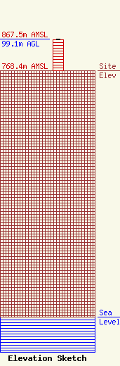
Site Elevation: 768.4 meters (2521 ft) |
| Height of Structure: 98.1 meters (322 feet) |
| Overall Height Above Ground: 99.1 meters (325 feet) |
| Overall Height Above Mean Sea Level: 867.5 meters (2846 feet) |
| Owner Info | Las Vegas Broadcasters, Inc.
3185 South Highland Drive
Las Vegas, NV 89109
(702) 325-8066
CAUEL@GATE.NET |
| Contact Info | Graham Brock, Inc.
24466
St. Simons Island, GA 31522-7466
Cathy McKay
(912) 638-8028
cathy@grahambrock.com |
