|
|
Antenna Structure Registration 1218671 |
 |
Registration Info | Registration Number: 1218671 |
| File Number: A1209169 |
| FAA Study: 00-ANM-1914-OE |
| FAA Issue Date: 10/12/2000 |
| Status: Constructed |
| Date Constructed: 05/25/2001 |
| FAA EMI: N |
| NEPA: N |
Structure Info
| Structure Type: TOWER |
| Structure Coordinates: 47-40-36.8 N 114-8-36.4 W (NAD 83) |
| Structure Coordinates: 47-40-37.0 N 114-08-33.0 W (Converted to NAD 27) |
| Structure Address: Radio Hill Just South Of Polson Mt |
| Structure City: Polson, MT |
| Structure County: Lake County |
| Painting & Lighting Info |
FAA Chapters: NONE |
Remarks: PRIOR FAA 86-ANM-0698-OE |
Remarks: Removed expiration date from determination. Scenario 1./jjs/case#635066 |
Remarks: PRIOR FAA 86-ANM-0698-OE |
Remarks: Removed expiration date from determination. Scenario 1./jjs/case#635066 |
| Elevation Info |
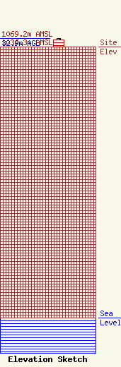
Site Elevation: 1036.3 meters (3400 ft) |
| Height of Structure: 27.4 meters (90 feet) |
| Overall Height Above Ground: 32.9 meters (108 feet) |
| Overall Height Above Mean Sea Level: 1069.2 meters (3508 feet) |
| Owner Info | Unison Towers US, LLC
2070
Hamilton, NY 01982
(212) 909-2515
mkasten@unisonsite.com |
| Contact Info | Unison Towers US, LLC
PO Box 2070
Hamilton, NY 01982
Mark Kasten
(212) 909-2515
mkasten@unisonsite.com |
