|
|
Antenna Structure Registration 1057339 |
 |
Registration Info | Registration Number: 1057339 |
| File Number: A0826746 |
| Status: Constructed |
| Date Constructed: 01/29/2013 |
| FAA EMI: N |
| NEPA: N |
Structure Info
| Structure Type: TOWER |
| Structure Coordinates: 42-57-31.0 N 124-16-27.0 W (NAD 83) |
| Structure Coordinates: 42-57-31.6 N 124-16-22.6 W (Converted to NAD 27) |
| Structure Address: 7km Ene Of Int. Us101 And Cr118, Bennet Butte |
| Structure City: Myrtle Point, OR |
| Structure County: Coos County |
| Painting & Lighting Info |
FCC Paragraph(s): None |
| Elevation Info |
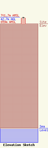
Site Elevation: 659 meters (2162 ft) |
| Height of Structure: 36.6 meters (120 feet) |
| Overall Height Above Ground: 42.7 meters (140 feet) |
| Overall Height Above Mean Sea Level: 701.7 meters (2302 feet) |
| Owner Info | PRIME SITE, INC. DBA = PRIME SITE, INC.
287 SOUTH 7TH STREET
COOS BAY, OR 97420
(541) 267-7190
|
