|
|
Antenna Structure Registration 1015427 |
 |
Registration Info | Registration Number: 1015427 |
| File Number: A1225508 |
| FAA Study: 2022-AWP-8481-OE |
| FAA Issue Date: 10/14/2022 |
| Status: Constructed |
| Date Constructed: 02/19/2004 |
| NEPA: N |
Structure Info
| Structure Type: GTOWER |
| Structure Coordinates: 33-14-50.4 N 111-31-52.2 W (NAD 83) |
| Structure Coordinates: 33-14-50.2 N 111-31-49.7 W (Converted to NAD 27) |
| Structure Address: 3243 E Ocotillo Rd (#204524) |
| Structure City: Queen Creek, AZ |
| Structure County: Pinal County |
| Painting & Lighting Info |
FAA Circular #: 70/7460-1L |
FAA Chapters: 4, 9, 12 |
Remarks: PRIOR STUDY 2019-AWP-1892-OE |
Remarks: OM&L to remain the same as prior study = A HIGH-DUAL SYSTEM |
Remarks: PRIOR STUDY 2019-AWP-1892-OE |
Remarks: OM&L to remain the same as prior study = A HIGH-DUAL SYSTEM |
| Elevation Info |
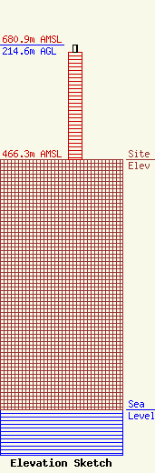
Site Elevation: 466.3 meters (1530 ft) |
| Height of Structure: 200.9 meters (659 feet) |
| Overall Height Above Ground: 214.6 meters (704 feet) |
| Overall Height Above Mean Sea Level: 680.9 meters (2234 feet) |
| Owner Info | American Towers LLC
10 Presidential Way
Woburn, MA 01801
(781) 926-4500
faa-fcc@americantower.com |
| Contact Info | American Towers, LLC
10 Presidential Way
Woburn, MA 01801
(781) 926-4500
faa-fcc@americantower.com |
