|
|
Antenna Structure Registration 1237195 |
 |
Registration Info | Registration Number: 1237195 |
| File Number: A0343038 |
| FAA Study: 2002-AWP-3720-OE |
| FAA Issue Date: 12/04/2002 |
| Status: Constructed |
| Date Constructed: 08/10/2003 |
| FAA EMI: N |
| NEPA: N |
Structure Info
| Structure Type: 3TA2 |
| Structure Coordinates: 35-10-8.0 N 114-38-12.0 W (NAD 83) |
| Structure Coordinates: 35-10-08.0 N 114-38-09.1 W (Converted to NAD 27) |
| Structure Address: Approx. 0.7 Mile West Of Int. Of Cougar Rd. & Needles Hwy., Clark Co. Nv |
| Structure City: Laughlin, NV |
| Structure County: Clark County |
| Painting & Lighting Info |
FAA Circular #: 70/7460-1K |
FAA Chapters: 4, 5, 12 |
Remarks: PRIOR STUDY 1984-AWP-0013-OE |
| Elevation Info |
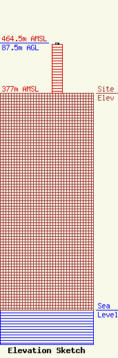
Site Elevation: 377 meters (1237 ft) |
| Height of Structure: 85.3 meters (280 feet) |
| Overall Height Above Ground: 87.5 meters (287 feet) |
| Overall Height Above Mean Sea Level: 464.5 meters (1524 feet) |
| Owner Info | Valley Broadcasting Company
1500 Foremaster Ln.
Las Vegas, NV 89101
(702) 642-3333
jlichstein@kvbc.com |
