|
|
Antenna Structure Registration 1002386 |
 |
Registration Info | Registration Number: 1002386 |
| File Number: A0904515 |
| Status: Terminated |
| Date Constructed: 01/01/1990 |
| FAA EMI: N |
| NEPA: N |
Structure Info
| Structure Type: TOWER |
| Structure Coordinates: 34-12-17.0 N 109-56-24.0 W (NAD 83) |
| Structure Coordinates: 34-12-16.8 N 109-56-21.6 W (Converted to NAD 27) |
| Structure Address: Porter Mountain Communications Site |
| Structure City: Pinetop/lakeside, AZ |
| Structure County: Navajo County |
| Painting & Lighting Info |
FCC Paragraph(s): None |
| Elevation Info |
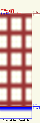
Site Elevation: 2315 meters (7595 ft) |
| Height of Structure: 38.1 meters (125 feet) |
| Overall Height Above Ground: 44 meters (144 feet) |
| Overall Height Above Mean Sea Level: 2359 meters (7740 feet) |
| Owner Info | American Towers, LLC.
10 Presidential Way
Woburn, MA 01801
(678) 564-3236
faa-fcc@americantower.com |
| Contact Info | American Towers, LLC.
10 Presidential Way
Woburn, MA 01801
(678) 564-3236
faa-fcc@americantower.com |
