|
|
Antenna Structure Registration 1037827 |
 |
Registration Info | Registration Number: 1037827 |
| File Number: A0931159 |
| FAA Study: 97-ANM-1349-OE |
| FAA Issue Date: 11/12/1997 |
| Status: Constructed |
| Date Constructed: 01/01/1986 |
| FAA EMI: N |
| NEPA: N |
Structure Info
| Structure Type: 2TA1 |
| Structure Coordinates: 47-18-20.0 N 122-14-57.0 W (NAD 83) |
| Structure Coordinates: 47-18-20.6 N 122-14-52.6 W (Converted to NAD 27) |
| Structure Address: Twr 1 - 1408 West Main Street |
| Structure City: Auburn, WA |
| Structure County: King County |
| Painting & Lighting Info |
FAA Chapters: NONE |
Remarks: CENTER OF ARRAY 47-18-20.1/122-14-52.2. 2TA1. CMS |
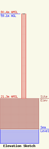
| Elevation Info |
Site Elevation: 21.3 meters (70 ft) |
| Height of Structure: 59.1 meters (194 feet) |
| Overall Height Above Ground: 59.1 meters (194 feet) |
| Overall Height Above Mean Sea Level: 80.4 meters (264 feet) |
| Owner Info | Bustos Media Holdings, LLC
5110 S.E. Stark Street
Portland, OR 97212
(503) 233-5280
abustos@bustosmedia.com |
| Contact Info | Law Office of Dennis J. Kelly
41177
Washington, DC 20018-0577
Dennis Kelly
(202) 293-2300
dkellyfcclaw1@comcast.net |
