|
|
Antenna Structure Registration 1253656 |
 |
Registration Info | Registration Number: 1253656 |
| File Number: A0506534 |
| FAA Study: 2006-AWP-1914-OE |
| FAA Issue Date: 05/10/2006 |
| Status: Granted |
| NEPA: N |
Structure Info
| Structure Type: POLE |
| Structure Coordinates: 39-14-46.6 N 120-57-51.8 W (NAD 83) |
| Structure Coordinates: 39-14-47.0 N 120-57-48.0 W (Converted to NAD 27) |
| Structure Address: Banner Mountain 2.1 Miles Se Of |
| Structure City: Nevada City, CA |
| Structure County: Nevada County |
| Painting & Lighting Info |
FAA Circular #: |
FAA Chapters: NONE |
Remarks: Removed expiration date from determination. Scenario 1./jjs/case#635066 |
| Elevation Info |
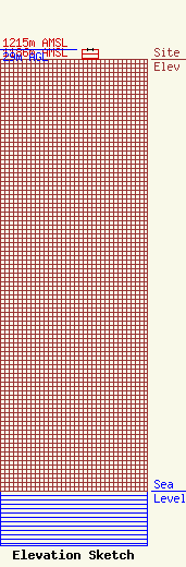
Site Elevation: 1186 meters (3891 ft) |
| Height of Structure: 29 meters (95 feet) |
| Overall Height Above Ground: 29 meters (95 feet) |
| Overall Height Above Mean Sea Level: 1215 meters (3986 feet) |
| Info |
| Contact Info | Haggerty Communications Group
7840 El Cajon Blvd. Suite 401
La Mesa, CA 91941
Robert Haggerty
(619) 698-9560
robert@haggerty.com |
