|
|
Antenna Structure Registration 1258092 |
 |
Registration Info | Registration Number: 1258092 |
| File Number: A0547385 |
| FAA Study: 2006-ANM-3807-OE |
| FAA Issue Date: 11/27/2006 |
| Status: Granted |
| NEPA: N |
Structure Info
| Structure Type: POLE |
| Structure Coordinates: 45-26-55.0 N 105-24-38.0 W (NAD 83) |
| Structure Coordinates: 45-26-55.0 N 105-24-36.0 W (Converted to NAD 27) |
| Structure Address: 100 Bee Hill Road |
| Structure City: Broadus, MT |
| Structure County: Powder River County |
| Painting & Lighting Info |
FAA Circular #: |
FAA Chapters: NONE |
| Elevation Info |
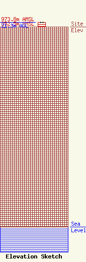
Site Elevation: 952.5 meters (3125 ft) |
| Height of Structure: 21.3 meters (70 feet) |
| Overall Height Above Ground: 21.3 meters (70 feet) |
| Overall Height Above Mean Sea Level: 973.8 meters (3195 feet) |
| Owner Info | Skyview TV, Inc.
105 N. Wilbur
445
Broadus, MT 59317
(404) 436-2820
|
