|
|
Antenna Structure Registration 1286460 |
 |
Registration Info | Registration Number: 1286460 |
| File Number: A0876824 |
| FAA Study: 98-ASW-0024-OE |
| FAA Issue Date: 02/03/1998 |
| Status: Constructed |
| Date Constructed: 01/13/1977 |
| FAA EMI: N |
Structure Info
| Structure Type: GTOWER |
| Structure Coordinates: 35-49-10.7 N 100-23-58.0 W (NAD 83) |
| Structure Coordinates: 35-49-10.5 N 100-23-56.5 W (Converted to NAD 27) |
| Structure Address: West Of Texas Hwy 60/83 7 Miles South Of Canadian Texas. |
| Structure City: Canadian, TX |
| Structure County: Hemphill County |
| Painting & Lighting Info |
FAA Circular #: 70/7460-1 |
FCC Paragraph(s): 1, 3, 11, 21 |
Remarks: RED LIGHTS/PAINT - PREVIOUS STUDY #73-SW-399-OE |
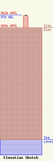
| Elevation Info |
Site Elevation: 866 meters (2841 ft) |
| Height of Structure: 92 meters (302 feet) |
| Overall Height Above Ground: 97 meters (318 feet) |
| Overall Height Above Mean Sea Level: 963 meters (3159 feet) |
| Owner Info | SAA Properties, LP
120 Main Street
7
Canadian, TX 79014
(806) 323-8000
larry@abrahamtrading.com |
| Contact Info | SAA Properties, LP
120 Main Street
7
Canadian, TX 79014
Larry Smith
(806) 323-8000
larry@abrahamtrading.com |
