|
|
Antenna Structure Registration 1019017 |
 |
Registration Info | Registration Number: 1019017 |
| File Number: A0624278 |
| FAA Study: 2009-ANM-170-OE |
| FAA Issue Date: 02/20/2009 |
| Status: Constructed |
| Date Constructed: 01/01/1991 |
| FAA EMI: N |
| NEPA: N |
Structure Info
| Structure Type: TOWER |
| Structure Coordinates: 43-12-7.4 N 123-22-58.3 W (NAD 83) |
| Structure Coordinates: 43-12-08.0 N 123-22-54.0 W (Converted to NAD 27) |
| Structure Address: Nebo Ridge 2.8 Km Sw Center Of Roseburg Or |
| Structure City: Roseburg Green, OR |
| Structure County: Douglas County |
| Painting & Lighting Info |
FAA Chapters: NONE |
Remarks: PRIOR STUDY 1996-ANM-1007-OE |
| Elevation Info |
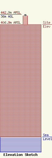
Site Elevation: 406.9 meters (1335 ft) |
| Height of Structure: 30.5 meters (100 feet) |
| Overall Height Above Ground: 36 meters (118 feet) |
| Overall Height Above Mean Sea Level: 442.9 meters (1453 feet) |
| Owner Info | JATCOM COMMUNICATIONS INC
22 S SECOND ST
CAMPBELL, CA 95008
(408) 370-6699
JATCOM@AOL.COM |
| Contact Info | Hatfield & Dawson Consulting Engineers
9500 Greenwood Ave N
Seattle, WA 98103
Erik Swanson
(206) 783-9151
eswanson@hatdaw.com |
