|
|
Antenna Structure Registration 1058831 |
 |
Registration Info | Registration Number: 1058831 |
| File Number: A1366258 |
| FAA Study: 2008-ASW-1038-OE |
| FAA Issue Date: 02/06/2008 |
| Status: Constructed |
| Date Constructed: 02/11/1998 |
| FAA EMI: N |
| NEPA: N |
Structure Info
| Structure Type: TOWER |
| Structure Coordinates: 30-25-39.7 N 91-4-44.3 W (NAD 83) |
| Structure Coordinates: 30-25-39.0 N 91-04-43.9 W (Converted to NAD 27) |
| Structure Address: Airline Highway |
| Structure City: Baton Rouge, LA |
| Structure County: East Baton Rouge Parish |
| Painting & Lighting Info |
FAA Circular #: 70/7460-1J |
FAA Chapters: 4, 8, 13 |
Remarks: PRIOR STUDY 2007-ASW-4046-OE |
Remarks: OM&L to remain the same as prior study = A MED-DUAL SYSTEM |
Remarks: PRIOR STUDY 2007-ASW-4046-OE |
Remarks: OM&L to remain the same as prior study = A MED-DUAL SYSTEM |
| Elevation Info |
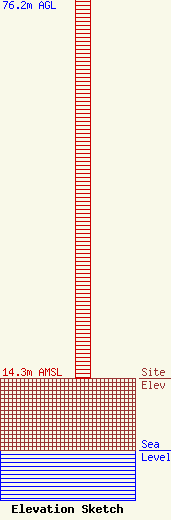
Site Elevation: 14.3 meters (47 ft) |
| Height of Structure: 76.2 meters (250 feet) |
| Overall Height Above Ground: 82.3 meters (270 feet) |
| Overall Height Above Mean Sea Level: 96.6 meters (317 feet) |
| Owner Info | Pinnacle Towers LLC
2000 Corporate Drive
Canonsburg, PA 15317
(724) 416-2400
Regulatory.Department@crowncastle.com |
| Contact Info | Crown Castle
2000 Corporate Drive
Canonsburg, PA 15317
Tom Anderson
(724) 743-6330
Tom.Anderson@crowncastle.com |
