|
|
Antenna Structure Registration 1005559 |
 |
Registration Info | Registration Number: 1005559 |
| File Number: A1229160 |
| FAA Study: 2016-AAL-364-OE |
| FAA Issue Date: 04/18/2016 |
| Status: Constructed |
| Date Constructed: 07/01/1994 |
| NEPA: N |
Structure Info
| Structure Type: LTOWER |
| Structure Coordinates: 58-7-39.4 N 135-25-58.4 W (NAD 83) |
| Structure Coordinates: 58-07-40.6 N 135-25-51.9 W (Converted to NAD 27) |
| Structure Address: 1.25 Mi Ne |
| Structure City: Hoonah, AK |
| Structure County: Hoonah-Angoon Census Area |
| Painting & Lighting Info |
FCC Paragraph(s): A1, H |
Remarks: PRIOR STUDY 1985-AAL-61-OE |
Remarks: Continue As Is OM&L = 24-HR MED-STROBES |
Remarks: PRIOR STUDY 1985-AAL-61-OE |
Remarks: Continue As Is OM&L = 24-HR MED-STROBES |
| Elevation Info |
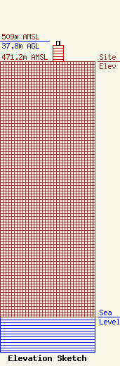
Site Elevation: 471.2 meters (1546 ft) |
| Height of Structure: 30.5 meters (100 feet) |
| Overall Height Above Ground: 37.8 meters (124 feet) |
| Overall Height Above Mean Sea Level: 509 meters (1670 feet) |
| Owner Info | Alascom Inc.
50 Royal Little Dr
Providence, RI 02904
(855) 699-7073
ATTNRC@att.com |
| Info |
