|
|
Antenna Structure Registration 1057791 |
 |
Registration Info | Registration Number: 1057791 |
| File Number: A0583677 |
| FAA Study: 98-ANM-1122-OE |
| FAA Issue Date: 03/16/1999 |
| Status: Constructed |
| Date Constructed: 04/28/1999 |
| FAA EMI: N |
| NEPA: N |
Structure Info
| Structure Type: TOWER |
| Structure Coordinates: 41-44-54.0 N 112-13-40.0 W (NAD 83) |
| Structure Coordinates: 41-44-54.3 N 112-13-37.2 W (Converted to NAD 27) |
| Structure Address: Lookout Mountain |
| Structure City: Tremonton, UT |
| Structure County: Box Elder County |
| Painting & Lighting Info |
FAA Circular #: 70/7460-1J |
FAA Chapters: 3, 4, 5, 13 |
Remarks: REFER TO PRIOR STUDY 98-ANM-0338-OE |
Remarks: Removed expiration and final dates from determination. Scenario 2./jjs/case#635066 |
Remarks: REFER TO PRIOR STUDY 98-ANM-0338-OE |
Remarks: Removed expiration and final dates from determination. Scenario 2./jjs/case#635066 |
| Elevation Info |
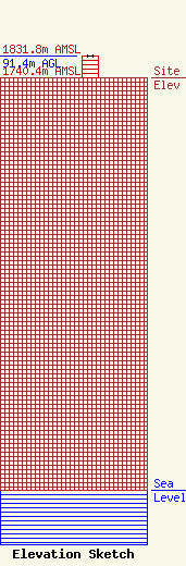
Site Elevation: 1740.4 meters (5710 ft) |
| Height of Structure: 90.5 meters (297 feet) |
| Overall Height Above Ground: 91.4 meters (300 feet) |
| Overall Height Above Mean Sea Level: 1831.8 meters (6010 feet) |
| Owner Info | FRANDSEN MEDIA COMPANY, LLC
570
LOGAN, UT 84323
(435) 752-1390
|
| Contact Info | Davis Wright Tremaine LLP
1919 Pennsylvania Ave., NW -- #200
Washington, DC 20006
Brendan Holland
(202) 973-4200
brendanholland@dwt.com |
