|
|
Antenna Structure Registration 1237668 |
 |
Registration Info | Registration Number: 1237668 |
| File Number: A1259245 |
| FAA Study: 2002-ANM-2315-OE |
| FAA Issue Date: 02/05/2003 |
| Status: Constructed |
| Date Constructed: 01/31/2003 |
| FAA EMI: N |
| NEPA: N |
Structure Info
| Structure Type: TOWER |
| Structure Coordinates: 47-27-22.3 N 115-39-2.0 W (NAD 83) |
| Structure Coordinates: 47-27-22.5 N 115-38-58.4 W (Converted to NAD 27) |
| Structure Address: 2 Miles N Of Interstate 90 Along Idaho/montana Border At Lookout Pass Elec Site |
| Structure City: Mullan, ID |
| Structure County: Shoshone County |
| Painting & Lighting Info |
FAA Chapters: NONE |
Remarks: Removed expiration date from determination. Scenario 1./jjs/case#635066 |
| Elevation Info |
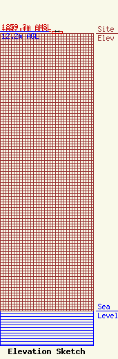
Site Elevation: 1847.1 meters (6060 ft) |
| Height of Structure: 12.2 meters (40 feet) |
| Overall Height Above Ground: 12.2 meters (40 feet) |
| Overall Height Above Mean Sea Level: 1859.3 meters (6100 feet) |
| Owner Info | Clearview Tower Company III, LLC
26 Yolanda Drive
Edison, NJ 08817
(732) 744-0652
smejia@clearviewtower.net |
| Contact Info | Clearview Tower Company III, LLC
26 Yolanda Drive
Edison, NJ 08817
Steven Mejia
(732) 735-9390
smejia@clearviewtower.net |
