|
|
Antenna Structure Registration 1228627 |
 |
Registration Info | Registration Number: 1228627 |
| File Number: A1191375 |
| FAA Study: 00-AWP-3205-OE |
| FAA Issue Date: 07/31/2001 |
| Status: Constructed |
| Date Constructed: 08/29/2001 |
| FAA EMI: N |
| NEPA: N |
Structure Info
| Structure Type: POLE |
| Structure Coordinates: 35-37-34.6 N 120-42-46.2 W (NAD 83) |
| Structure Coordinates: 35-37-34.7 N 120-42-42.6 W (Converted to NAD 27) |
| Structure Address: 1512 Peachy Canyon Road |
| Structure City: Paso Robles, CA |
| Structure County: San Luis Obispo County |
| Painting & Lighting Info |
FAA Chapters: NONE |
Remarks: PRIOR STUDY 00-AWP-0892-OE |
Remarks: Removed expiration date from determination. Scenario 1./jjs/case#635066 |
Remarks: PRIOR STUDY 00-AWP-0892-OE |
Remarks: Removed expiration date from determination. Scenario 1./jjs/case#635066 |
| Elevation Info |
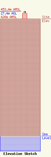
Site Elevation: 426 meters (1398 ft) |
| Height of Structure: 21.3 meters (70 feet) |
| Overall Height Above Ground: 27.4 meters (90 feet) |
| Overall Height Above Mean Sea Level: 453.4 meters (1488 feet) |
| Owner Info | Thornton Family Trust U/T/D December 6, 2004
1110
Paso Robles, CA 93447-1110
(805) 239-3400
admin@pasoroblesradioranch.com |
| Contact Info | Thornton Family Trust U/T/D December 6, 2004
1110
Paso Robles, CA 93447-1110
(805) 239-3400
admin@pasoroblesradioranch.com |
