|
|
Antenna Structure Registration 1051712 |
 |
Registration Info | Registration Number: 1051712 |
| File Number: A1130137 |
| FAA Study: 93-ASW-2068-OE |
| FAA Issue Date: 03/10/1994 |
| Status: Constructed |
| Date Constructed: 10/08/1995 |
| FAA EMI: N |
| NEPA: N |
Structure Info
| Structure Type: TOWER |
| Structure Coordinates: 33-11-0.0 N 96-3-20.0 W (NAD 83) |
| Structure Coordinates: 33-10-59.6 N 96-03-19.1 W (Converted to NAD 27) |
| Structure Address: Hwy 224 And Cr4200, 4 Miles Ne |
| Structure City: Greenville, TX |
| Structure County: Hunt County |
| Painting & Lighting Info |
FAA Circular #: 70/7460-1H |
FAA Chapters: 3, 4, 5, 13 |
| Elevation Info |
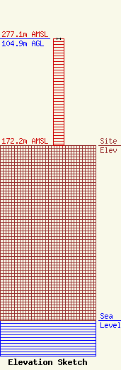
Site Elevation: 172.2 meters (565 ft) |
| Height of Structure: 104.5 meters (343 feet) |
| Overall Height Above Ground: 104.9 meters (344 feet) |
| Overall Height Above Mean Sea Level: 277.1 meters (909 feet) |
| Owner Info | E RADIO NETWORK, LLC
1517 WOLFE CITY DR
GREENVILLE, TX 75401
(903) 455-1400
ChristieT@eradio935.com |
| Contact Info | E RADIO NETWORK, LLC
1517 WOLFE CITY DR
GREENVILLE, TX 75401
Christie Tate
(903) 455-1400
ChristieT@eradio935.com |
