|
|
Antenna Structure Registration 1267564 |
 |
Registration Info | Registration Number: 1267564 |
| File Number: A0656773 |
| FAA Study: 2009-ANM-112-OE |
| FAA Issue Date: 02/20/2009 |
| Status: Constructed |
| Date Constructed: 07/02/2009 |
| FAA EMI: N |
| NEPA: N |
Structure Info
| Structure Type: TOWER |
| Structure Coordinates: 40-30-50.7 N 107-26-26.6 W (NAD 83) |
| Structure Coordinates: 40-30-50.8 N 107-26-24.4 W (Converted to NAD 27) |
| Structure Address: 5.5 Miles East Of |
| Structure City: Craig, CO |
| Structure County: Moffat County |
| Painting & Lighting Info |
FAA Chapters: NONE |
Remarks: Removed expiration date from determination. Scenario 1./jjs/case#635066 |
| Elevation Info |
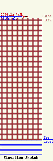
Site Elevation: 1997.7 meters (6554 ft) |
| Height of Structure: 25 meters (82 feet) |
| Overall Height Above Ground: 26.5 meters (87 feet) |
| Overall Height Above Mean Sea Level: 2024.2 meters (6641 feet) |
| Owner Info | Union Telephone Company
850 N Hwy 414
160
Mountain View, WY 82939
(307) 782-4115
ejensen@Unionwireless.com |
| Contact Info | Lukas, Nace, Gutierrez & Sachs, LLP
8300 Greensboro Drive, Suite 1200
McLean, VA 22102
Pamela Gist
(703) 584-8665
pgist@fcclaw.com |
