|
|
Antenna Structure Registration 1247560 |
 |
Registration Info | Registration Number: 1247560 |
| File Number: A1308604 |
| FAA Study: 2003-AAL-668-OE |
| FAA Issue Date: 12/19/2003 |
| Status: Constructed |
| Date Constructed: 08/04/2006 |
| FAA EMI: Y |
| NEPA: N |
Structure Info
| Structure Type: TOWER |
| Structure Coordinates: 61-20-10.0 N 149-30-53.0 W (NAD 83) |
| Structure Coordinates: 61-20-12.0 N 149-30-45.0 W (Converted to NAD 27) |
| Structure Address: End Of Skyline Drive |
| Structure City: Eagle River, AK |
| Structure County: Anchorage Municipality |
| Painting & Lighting Info |
FAA Chapters: NONE |
Remarks: Removed expiration date from determination. Scenario 1./jjs/case#635066 |
| Elevation Info |
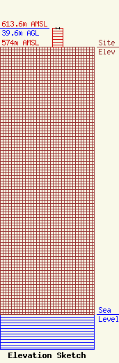
Site Elevation: 574 meters (1883 ft) |
| Height of Structure: 39.6 meters (130 feet) |
| Overall Height Above Ground: 39.6 meters (130 feet) |
| Overall Height Above Mean Sea Level: 613.6 meters (2013 feet) |
| Owner Info | Cell Ventures Capital, LLC
57 E Washington Street
Chagrin Falls, OH 44022
(440) 528-0333
rlepene@k2towers.com |
| Contact Info | Cell Ventures Capital, LLC
57 E Washington Street
Chagrin Falls, OH 44022
Greg Thompson
(440) 528-0333
gthompson@k2towers.com |
