|
|
Antenna Structure Registration 1218381 |
 |
Registration Info | Registration Number: 1218381 |
| File Number: A1205911 |
| FAA Study: 00-ANM-0882-OE |
| FAA Issue Date: 02/19/2002 |
| Status: Constructed |
| Date Constructed: 02/19/2002 |
| FAA EMI: N |
| NEPA: N |
Structure Info
| Structure Type: TOWER |
| Structure Coordinates: 46-30-20.4 N 104-12-38.2 W (NAD 83) |
| Structure Coordinates: 46-30-20.4 N 104-12-36.4 W (Converted to NAD 27) |
| Structure Address: Atop Schweiger Hill 16 Km Ne Of Baker Mt |
| Structure City: Baker, MT |
| Structure County: Fallon County |
| Painting & Lighting Info |
FAA Circular #: 70/7460-1K |
FAA Chapters: 3, 4, 5, 12 |
Remarks: Removed expiration date from determination. Scenario 1./jjs/case#635066 |
| Elevation Info |
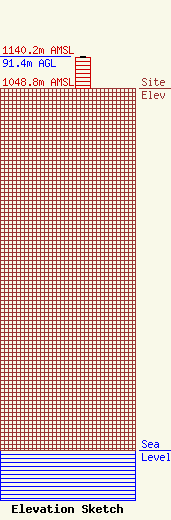
Site Elevation: 1048.8 meters (3441 ft) |
| Height of Structure: 90.5 meters (297 feet) |
| Overall Height Above Ground: 91.4 meters (300 feet) |
| Overall Height Above Mean Sea Level: 1140.2 meters (3741 feet) |
| Owner Info | Newell Media, LLC
5207 Rocky Mountain Blvd.
Billings, MT 59106
(406) 671-9180
jay@radiobaker.com |
| Contact Info | Newell Media, LLC
5207 Rocky Mountain Blvd.
Billings, MT 59106
Jay Newell
(406) 671-9180
jay@radiobaker.com |
