|
|
Antenna Structure Registration 1267995 |
 |
Registration Info | Registration Number: 1267995 |
| File Number: A0631606 |
| FAA Study: 2008-ANM-3350-OE |
| FAA Issue Date: 02/27/2009 |
| Status: Constructed |
| Date Constructed: 04/17/2009 |
| FAA EMI: N |
| NEPA: N |
Structure Info
| Structure Type: TOWER |
| Structure Coordinates: 44-11-50.8 N 120-58-40.5 W (NAD 83) |
| Structure Coordinates: 44-11-51.4 N 120-58-36.4 W (Converted to NAD 27) |
| Structure Address: Powell Butte, Oregon |
| Structure City: Prineville, OR |
| Structure County: Crook County |
| Painting & Lighting Info |
FAA Chapters: NONE |
Remarks: Removed expiration date from determination. Scenario 1./jjs/case#635066 |
| Elevation Info |
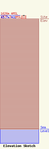
Site Elevation: 1577.3 meters (5175 ft) |
| Height of Structure: 45.7 meters (150 feet) |
| Overall Height Above Ground: 48.7 meters (160 feet) |
| Overall Height Above Mean Sea Level: 1626 meters (5335 feet) |
| Owner Info | Day Management Corp. dba Day Wireless Systems
4700 SE International Way
22169
Milwaukie, OR 97222
(503) 659-1240
tfeldsher@daywireless.com |
| Contact Info | Day Wireless Systems
4700 SE International Way
22169
Milwaukie, OR 97222
Dean Ballew
(503) 659-1240
dballew@daywireless.com |
