|
|
Antenna Structure Registration 1038004 |
 |
Registration Info | Registration Number: 1038004 |
| File Number: A1279426 |
| FAA Study: 97-ASW-2264-OE |
| FAA Issue Date: 09/10/1997 |
| Status: Constructed |
| Date Constructed: 07/26/1989 |
| FAA EMI: N |
| NEPA: N |
Structure Info
| Structure Type: TOWER |
| Structure Coordinates: 36-23-37.0 N 94-10-54.0 W (NAD 83) |
| Structure Coordinates: 36-23-36.7 N 94-10-53.3 W (Converted to NAD 27) |
| Structure Address: 2 Mi Nw |
| Structure City: Bentonville, AR |
| Structure County: Benton County |
| Painting & Lighting Info |
FAA Circular #: 70/7460-1J |
FAA Chapters: 4, 8, 13 |
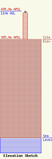
| Elevation Info |
Site Elevation: 385.9 meters (1266 ft) |
| Height of Structure: 103.9 meters (341 feet) |
| Overall Height Above Ground: 110 meters (361 feet) |
| Overall Height Above Mean Sea Level: 495.9 meters (1627 feet) |
| Owner Info | K2 Towers III, LLC
57 E Washington St
Chagrin Falls, OH 44022
(440) 528-0333
rlepene@peppertreecapital.com |
| Contact Info | K2 Towers III, LLC
57 E Washington Street
Chagrin Falls, OH 44022
Greg Thompson
(440) 528-0333
gthompson@k2towers.com |
