|
|
Antenna Structure Registration 1012207 |
 |
Registration Info | Registration Number: 1012207 |
| File Number: A1100807 |
| FAA Study: 2017-ASW-18278-OE |
| FAA Issue Date: 11/21/2017 |
| Status: Constructed |
| Date Constructed: 06/10/1997 |
| NEPA: N |
Structure Info
| Structure Type: GTOWER |
| Structure Coordinates: 30-8-3.0 N 98-40-21.0 W (NAD 83) |
| Structure Coordinates: 30-08-02.3 N 98-40-19.9 W (Converted to NAD 27) |
| Structure Address: 6 Mi N From Road 1888 |
| Structure City: Luckenbach, TX |
| Structure County: Kendall County |
| Painting & Lighting Info |
FAA Circular #: 70/7460-1L |
FAA Chapters: 4, 8, 12 |
Remarks: PRIOR STUDY 1996-ASW-1598-OE |
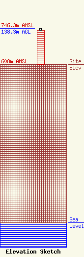
| Elevation Info |
Site Elevation: 608 meters (1995 ft) |
| Height of Structure: 131 meters (430 feet) |
| Overall Height Above Ground: 138.3 meters (454 feet) |
| Overall Height Above Mean Sea Level: 746.3 meters (2448 feet) |
| Owner Info | Vertical Bridge S3 Assets, LLC
750 Park of Commerce Dr.
Boca Raton, FL 33487
(561) 406-4015
FCC-FAA@verticalbridge.com |
| Contact Info | Vertical Bridge S3 Assets, LLC
750 Park of Commerce Dr.
Boca Raton, FL 33487
Richard Hickey
(561) 406-4015
FCC-FAA@verticalbridge.com |
