|
|
Antenna Structure Registration 1250431 |
 |
Registration Info | Registration Number: 1250431 |
| File Number: A1122586 |
| FAA Study: 2017-AWP-12021-OE |
| FAA Issue Date: 12/07/2017 |
| Status: Constructed |
| Date Constructed: 01/01/1958 |
| NEPA: N |
Structure Info
| Structure Type: GTOWER |
| Structure Coordinates: 35-20-59.1 N 118-58-52.1 W (NAD 83) |
| Structure Coordinates: 35-20-59.2 N 118-58-48.7 W (Converted to NAD 27) |
| Structure Address: 200' South Of The Intersection Of Feliz And Franco Streets |
| Structure City: Bakersfield, CA |
| Structure County: Kern County |
| Painting & Lighting Info |
FCC Paragraph(s): 1, 3, 11, 21 |
Remarks: Continue As Is OM&L = PAINT/RED LIGHTS |
Remarks: PRIOR STUDY 2005-AWP-5130-OE |
Remarks: Continue As Is OM&L = PAINT/RED LIGHTS |
Remarks: PRIOR STUDY 2005-AWP-5130-OE |
| Elevation Info |
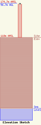
Site Elevation: 118 meters (387 ft) |
| Height of Structure: 54.9 meters (180 feet) |
| Overall Height Above Ground: 56.7 meters (186 feet) |
| Overall Height Above Mean Sea Level: 174.7 meters (573 feet) |
| Owner Info | Punjabi American Media, LLC
3750 McKee Road, Suite A
San Jose, CA 95127
(408) 272-2500
harjot@khalsainsurance.com |
| Contact Info | Law Office of Dennis J. Kelly
Post Office Box 41177
Washington, DC 20018-0577
Dennis Kelly
(202) 293-2300
dkellyfcclaw1@comcast.net |
