|
|
Antenna Structure Registration 1237628 |
 |
Registration Info | Registration Number: 1237628 |
| File Number: A0627226 |
| FAA Study: 2007-ACE-448-OE |
| FAA Issue Date: 03/08/2007 |
| Status: Constructed |
| Date Constructed: 05/27/2007 |
| FAA EMI: N |
| NEPA: N |
Structure Info
| Structure Type: TOWER |
| Structure Coordinates: 37-3-55.1 N 95-45-1.9 W (NAD 83) |
| Structure Coordinates: 37-03-54.8 N 95-45-01.0 W (Converted to NAD 27) |
| Structure Address: Intersection Of Cr220 And Cr3500, Independence, Ks |
| Structure City: Independence, KS |
| Structure County: Montgomery County |
| Painting & Lighting Info |
FAA Circular #: 70/7460-1K |
FAA Chapters: 3, 4, 5, 12 |
Remarks: Removed expiration date from determination. Scenario 1./jjs/case#635066 |
Remarks: PRIOR STUDY 2002-ACE-2388-OE |
Remarks: Removed expiration date from determination. Scenario 1./jjs/case#635066 |
Remarks: PRIOR STUDY 2002-ACE-2388-OE |
| Elevation Info |
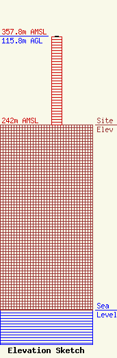
Site Elevation: 242 meters (794 ft) |
| Height of Structure: 114.8 meters (377 feet) |
| Overall Height Above Ground: 115.8 meters (380 feet) |
| Overall Height Above Mean Sea Level: 357.8 meters (1174 feet) |
| Owner Info | Community Broadcasting, Inc.
10550 Barkley
Overland Park, KS 66212
(913) 642-7600
|
| Contact Info | Community Broadcasting, Inc.
10550 Barkley
Overland Park, KS 66212
Eben Fowler
(913) 642-7600
efowler@bottradionetwork.com |
