|
|
Antenna Structure Registration 1058475 |
 |
Registration Info | Registration Number: 1058475 |
| File Number: A0654147 |
| FAA Study: 98-ASW-1158-OE |
| FAA Issue Date: 11/30/1998 |
| Status: Constructed |
| Date Constructed: 08/02/1999 |
| FAA EMI: N |
| NEPA: N |
Structure Info
| Structure Type: TOWER |
| Structure Coordinates: 35-0-8.0 N 91-44-41.0 W (NAD 83) |
| Structure Coordinates: 35-00-07.7 N 91-44-40.5 W (Converted to NAD 27) |
| Structure Address: 1/4 Mi N Of The Int Of Hwy 13 & 38 |
| Structure City: Hickory Plains, AR |
| Structure County: Prairie County |
| Painting & Lighting Info |
FAA Circular #: 70/7460-1J |
FAA Chapters: 4, 6, 13 |
Remarks: Removed expiration and final dates from determination. Scenario 2./jjs/case#635066 |
| Elevation Info |
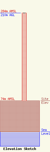
Site Elevation: 74 meters (243 ft) |
| Height of Structure: 210 meters (689 feet) |
| Overall Height Above Ground: 210 meters (689 feet) |
| Overall Height Above Mean Sea Level: 284 meters (932 feet) |
| Owner Info | AMERICAN FAMILY ASSOCIATION
P.O. DRAWER 2440
TUPELO, MS 38803
(662) 844-8888
JES@AFA.NET |
