|
|
Antenna Structure Registration 1238215 |
 |
Registration Info | Registration Number: 1238215 |
| File Number: A1314470 |
| FAA Study: 91-ASW-0621-OE |
| FAA Issue Date: 08/14/1991 |
| Status: Cancelled |
| NEPA: N |
Structure Info
|
| Structure Coordinates: 30-11-49.7 N 98-38-20.1 W (NAD 83) |
| Structure Coordinates: 30-11-49.0 N 98-38-19.0 W (Converted to NAD 27) |
| Structure Address: 3 Miles Sse Of Stonewall, Tx, South Of Albert Road |
| Structure City: Stonewall, TX |
| Structure County: Gillespie County |
| Painting & Lighting Info |
FAA Circular #: 70/7460-1H |
FAA Chapters: 3, 4, 5, 13 |
| Elevation Info |
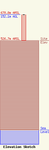
Site Elevation: 526.7 meters (1728 ft) |
| Height of Structure: 151.2 meters (496 feet) |
| Overall Height Above Ground: 152.1 meters (499 feet) |
| Overall Height Above Mean Sea Level: 678.8 meters (2227 feet) |
| Owner Info | Fritz Broadcasting Company, Inc.
210 Woodcrest
311
Fredericksburg, TX 78624
(830) 997-2197
|
