|
|
Antenna Structure Registration 1211604 |
 |
Registration Info | Registration Number: 1211604 |
| File Number: A0654162 |
| FAA Study: 00-ACE-0060-OE |
| FAA Issue Date: 03/06/2000 |
| Status: Constructed |
| Date Constructed: 06/13/2002 |
| FAA EMI: N |
| NEPA: N |
Structure Info
| Structure Type: TOWER |
| Structure Coordinates: 37-3-11.2 N 96-6-7.9 W (NAD 83) |
| Structure Coordinates: 37-03-11.0 N 96-06-06.9 W (Converted to NAD 27) |
| Structure Address: Eagle Road, 1/10 Mile West Of Cr25 |
| Structure City: Peru, KS |
| Structure County: Chautauqua County |
| Painting & Lighting Info |
FAA Circular #: 70/7460-1J |
FAA Chapters: 4, 6, 13 |
Remarks: Removed expiration date from determination. Scenario 1./jjs/case#635066 |
| Elevation Info |
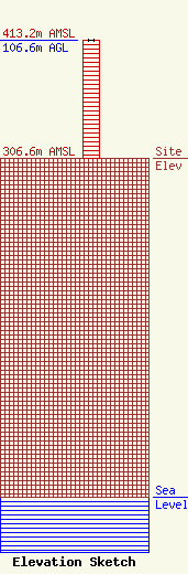
Site Elevation: 306.6 meters (1006 ft) |
| Height of Structure: 106.6 meters (350 feet) |
| Overall Height Above Ground: 106.6 meters (350 feet) |
| Overall Height Above Mean Sea Level: 413.2 meters (1356 feet) |
| Owner Info | AMERICAN FAMILY ASSOCIATION
P.O. DRAWER 2440
TUPELO, MS 38803
(662) 844-8888
JES@AFA.NET |
| Info |
