|
|
Antenna Structure Registration 1024630 |
 |
Registration Info | Registration Number: 1024630 |
| File Number: A1122619 |
| FAA Study: 2017-AGL-21453-OE |
| FAA Issue Date: 12/27/2017 |
| Status: Constructed |
| Date Constructed: 01/01/1979 |
| NEPA: N |
Structure Info
| Structure Type: GTOWER |
| Structure Coordinates: 46-45-35.5 N 96-36-27.0 W (NAD 83) |
| Structure Coordinates: 46-45-35.6 N 96-36-25.7 W (Converted to NAD 27) |
| Structure Address: 9143 90th Avenue South (mn22222-a) |
| Structure City: Sabin, MN |
| Structure County: Clay County |
| Painting & Lighting Info |
FAA Circular #: 70/7460-1L |
FAA Chapters: 3, 4, 5, 12 |
| Elevation Info |
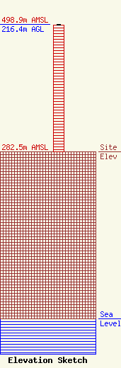
Site Elevation: 282.5 meters (927 ft) |
| Height of Structure: 214.6 meters (704 feet) |
| Overall Height Above Ground: 216.4 meters (710 feet) |
| Overall Height Above Mean Sea Level: 498.9 meters (1637 feet) |
| Owner Info | SBA Towers IX, LLC
8051 Congress Avenue
Boca Raton, FL 33487
(561) 995-7670
ERoach@sbasite.com |
| Contact Info | SBA Towers IX, LLC
8051 Congress Avenue
Boca Raton, FL 33487
(561) 995-7670
ERoach@sbasite.com |
