|
|
Antenna Structure Registration 1053309 |
 |
Registration Info | Registration Number: 1053309 |
| File Number: A0062718 |
| FAA Study: 97-ACE-1342-OE |
| FAA Issue Date: 04/08/1998 |
| Status: Constructed |
| Date Constructed: 11/09/1998 |
| NEPA: N |
Structure Info
| Structure Type: TOWER |
| Structure Coordinates: 39-26-2.0 N 92-14-25.0 W (NAD 83) |
| Structure Coordinates: 39-26-01.9 N 92-14-24.4 W (Converted to NAD 27) |
| Structure Address: 2.7 Km West Of Route 151, Approximately 6 Km Sw In Monroe Co. |
| Structure City: Madison, MO |
| Structure County: Monroe County |
| Painting & Lighting Info |
FAA Circular #: 70/7460-1J |
FAA Chapters: 3, 4, 5, 13 |
Remarks: Removed expiration and final dates from determination. Scenario 2./jjs/case#635066 |
Remarks: STRUCTURE REACHED ITS GREATEST HEIGHT 11-9-98. |
| Elevation Info |
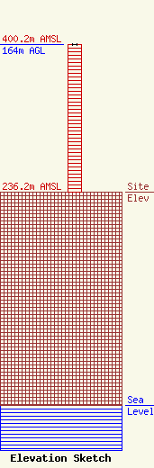
Site Elevation: 236.2 meters (775 ft) |
| Height of Structure: 164 meters (538 feet) |
| Overall Height Above Ground: 164 meters (538 feet) |
| Overall Height Above Mean Sea Level: 400.2 meters (1313 feet) |
| Owner Info | CHIRILLO ELECTRONICS, INC.
408 WEST REED
219
MOBERLY, MO 65270
(660) 263-0307
|
