|
|
Antenna Structure Registration 1037669 |
 |
Registration Info | Registration Number: 1037669 |
| File Number: A1278318 |
| FAA Study: 95-ASW-0590-OE |
| FAA Issue Date: 06/13/1995 |
| Status: Constructed |
| Date Constructed: 12/08/1995 |
| FAA EMI: N |
| NEPA: N |
Structure Info
| Structure Type: TOWER |
| Structure Coordinates: 36-21-38.0 N 93-44-55.0 W (NAD 83) |
| Structure Coordinates: 36-21-37.7 N 93-44-54.3 W (Converted to NAD 27) |
| Structure Address: 1.8 Mi S Jct Hwys 23 & 62 |
| Structure City: Eureka Springs, AR |
| Structure County: Carroll County |
| Painting & Lighting Info |
FAA Circular #: 70/7460-1H |
FAA Chapters: 3, 4, 5, 13 |
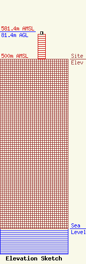
| Elevation Info |
Site Elevation: 500 meters (1640 ft) |
| Height of Structure: 73.1 meters (240 feet) |
| Overall Height Above Ground: 81.4 meters (267 feet) |
| Overall Height Above Mean Sea Level: 581.4 meters (1907 feet) |
| Owner Info | K2 Towers III, LLC
57 E Washington St
Chagrin Falls, OH 44022
(440) 528-0333
rlepene@k2towers.com |
| Contact Info | K2 Towers III, LLC
57 E Washington Street
Chagrin Falls, OH 44022
Greg Thompson
(440) 528-0333
gthompson@k2towers.com |
