|
|
Antenna Structure Registration 1274666 |
 |
Registration Info | Registration Number: 1274666 |
| File Number: A0785946 |
| FAA Study: 2009-ACE-2203-OE |
| FAA Issue Date: 01/13/2010 |
| Status: Constructed |
| Date Constructed: 12/23/2010 |
| FAA EMI: N |
| NEPA: N |
Structure Info
| Structure Type: TOWER |
| Structure Coordinates: 38-32-55.1 N 100-57-38.6 W (NAD 83) |
| Structure Coordinates: 38-32-55.0 N 100-57-37.1 W (Converted to NAD 27) |
| Structure Address: 3 Miles (4.8 Km) West And 4.5 Miles (7.2 Km) North Of Scott City |
| Structure City: Scott City, KS |
| Structure County: Scott County |
| Painting & Lighting Info |
FAA Circular #: 70/7460-1K |
FAA Chapters: 3, 4, 5, 12 |
Remarks: Removed expiration date from determination. Scenario 1./jjs/case#635066 |
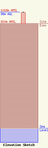
| Elevation Info |
Site Elevation: 920 meters (3018 ft) |
| Height of Structure: 97 meters (318 feet) |
| Overall Height Above Ground: 98 meters (322 feet) |
| Overall Height Above Mean Sea Level: 1018 meters (3340 feet) |
| Owner Info | GREAT PLAINS CHRISTIAN RADIO, INC.
909 W. CARTHAGE
991
MEADE, KS 67864
(620) 873-2991
DON@KJIL.COM |
