|
|
Antenna Structure Registration 1014626 |
 |
Registration Info | Registration Number: 1014626 |
| File Number: A1245757 |
| FAA Study: 2013-AWP-7715-OE |
| FAA Issue Date: 01/21/2014 |
| Status: Constructed |
| Date Constructed: 10/09/1997 |
| NEPA: N |
Structure Info
| Structure Type: LTOWER |
| Structure Coordinates: 37-52-54.2 N 121-55-8.8 W (NAD 83) |
| Structure Coordinates: 37-52-54.5 N 121-55-04.9 W (Converted to NAD 27) |
| Structure Address: Mt. Diablo State Park, Top Of Mt. Diablo (008501 / Mt Diablo Ca) |
| Structure City: Clayton, CA |
| Structure County: Contra Costa County |
| Painting & Lighting Info |
FAA Circular #: 70/7460-1K |
FAA Chapters: 4, 8, 12 |
Remarks: PRIOR STUDY 2013-AWP-2428-OE |
Remarks: OM&L to remain the same as prior study = A MED-DUAL SYSTEM |
Remarks: PRIOR STUDY 2013-AWP-2428-OE |
Remarks: OM&L to remain the same as prior study = A MED-DUAL SYSTEM |
| Elevation Info |
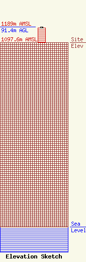
Site Elevation: 1097.6 meters (3601 ft) |
| Height of Structure: 85.3 meters (280 feet) |
| Overall Height Above Ground: 91.4 meters (300 feet) |
| Overall Height Above Mean Sea Level: 1189 meters (3901 feet) |
| Owner Info | CALIFORNIA, STATE OF
601 SEQUOIA PACIFIC BLVD
SACRAMENTO, CA 95811-0231
(916) 657-6153
radiolicensing@caloes.ca.gov |
| Contact Info | CALIFORNIA, STATE OF
601 SEQUOIA PACIFIC BLVD
SACRAMENTO, CA 95811-0231
JOHN LEMMON
(916) 657-6153
radiolicensing@caloes.ca.gov |
