|
|
Antenna Structure Registration 1213130 |
 |
Registration Info | Registration Number: 1213130 |
| File Number: A0458364 |
| FAA Study: 2004-ANM-352-OE |
| FAA Issue Date: 04/18/2006 |
| Status: Granted |
| Date Constructed: 11/26/1994 |
| NEPA: N |
Structure Info
| Structure Type: TOWER |
| Structure Coordinates: 42-51-45.6 N 112-31-5.9 W (NAD 83) |
| Structure Coordinates: 42-51-45.9 N 112-31-03.0 W (Converted to NAD 27) |
| Structure Address: On Howard Mountain West Of Pocatello 1/2 Mile |
| Structure City: Pocatello, ID |
| Structure County: Power County |
| Painting & Lighting Info |
FAA Circular #: 70/7460-1K |
FAA Chapters: 3, 4, 5, 12 |
Remarks: PRIOR STUDY 2000-ANM-50-OE |
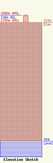
| Elevation Info |
Site Elevation: 1780 meters (5840 ft) |
| Height of Structure: 105 meters (344 feet) |
| Overall Height Above Ground: 106 meters (348 feet) |
| Overall Height Above Mean Sea Level: 1886 meters (6188 feet) |
| Owner Info | Idaho Wireless Inc
436 N Main
97
Pocatello, ID 83204
(208) 234-1290
paul@kzbq.com |
| Contact Info | idaho Wireless Corporation
436 North main Street
97
Pocatello, ID 83204
Paul Anderson
(208) 234-1290
paul@kzbq.com |
