|
|
Antenna Structure Registration 1241989 |
 |
Registration Info | Registration Number: 1241989 |
| File Number: A0654182 |
| FAA Study: 2003-ASW-5952-OE |
| FAA Issue Date: 12/22/2003 |
| Status: Constructed |
| Date Constructed: 01/24/2006 |
| FAA EMI: N |
| NEPA: N |
Structure Info
| Structure Type: TOWER |
| Structure Coordinates: 32-10-40.0 N 93-55-3.0 W (NAD 83) |
| Structure Coordinates: 32-10-39.4 N 93-55-02.3 W (Converted to NAD 27) |
| Structure Address: End Of Fisher-davis Road |
| Structure City: Mansfield, LA |
| Structure County: De Soto Parish |
| Painting & Lighting Info |
FAA Circular #: 70/7460-1K |
FAA Chapters: 4, 6, 12 |
| Elevation Info |
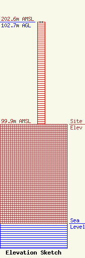
Site Elevation: 99.9 meters (328 ft) |
| Height of Structure: 102.7 meters (337 feet) |
| Overall Height Above Ground: 102.7 meters (337 feet) |
| Overall Height Above Mean Sea Level: 202.6 meters (665 feet) |
| Owner Info | AMERICAN FAMILY ASSOCIATION
P.O. DRAWER 2440
TUPELO, MS 38803
(662) 844-8888
JES@AFA.NET |
