|
|
Antenna Structure Registration 1027242 |
 |
Registration Info | Registration Number: 1027242 |
| File Number: A1243970 |
| FAA Study: 97-ACE-0984-OE |
| FAA Issue Date: 08/21/1997 |
| Status: Constructed |
| Date Constructed: 01/01/1997 |
| NEPA: N |
Structure Info
| Structure Type: TOWER |
| Structure Coordinates: 40-15-46.0 N 100-53-32.0 W (NAD 83) |
| Structure Coordinates: 40-15-46.0 N 100-53-30.4 W (Converted to NAD 27) |
| Structure Address: 3.2 Km W On Hwy 6-34 & 3.2 Km Nw |
| Structure City: Culbertson, NE |
| Structure County: Hitchcock County |
| Painting & Lighting Info |
FAA Circular #: 70/7460-1J |
FAA Chapters: 4, 6, 13 |
| Elevation Info |
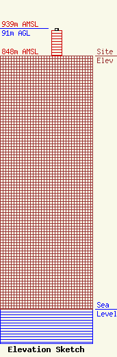
Site Elevation: 848 meters (2782 ft) |
| Height of Structure: 85 meters (279 feet) |
| Overall Height Above Ground: 91 meters (299 feet) |
| Overall Height Above Mean Sea Level: 939 meters (3081 feet) |
| Owner Info | Nebraska Educational Telecommunications Commission
1800 N. 33rd Street
Lincoln, NE 68503
(402) 472-9333
msperling@netad.unl.edu |
| Contact Info | Nebraska Educational Telecommunications Commission
1800 N. 33rd Street
Lincoln, NE 68503
Matthew Sperling
(402) 472-9333
msperling@netad.unl.edu |
