|
|
Antenna Structure Registration 1208423 |
 |
Registration Info | Registration Number: 1208423 |
| File Number: A0109886 |
| FAA Study: 116741-NH |
| FAA Issue Date: 04/09/1992 |
| Status: Granted |
| NEPA: N |
Structure Info
| Structure Type: B |
| Structure Coordinates: 43-35-46.2 N 71-44-38.2 W (NAD 83) |
| Structure Coordinates: 43-35-45.9 N 71-44-39.9 W (Converted to NAD 27) |
| Structure Address: 230 Lake Street |
| Structure City: Bristol, NH |
| Structure County: Grafton County |
| Painting & Lighting Info |
FAA Circular #: |
FAA Chapters: NONE |
| Elevation Info |
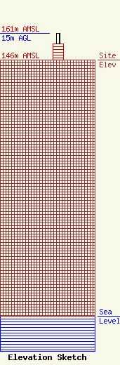
Site Elevation: 146 meters (479 ft) |
| Height of Structure: 9 meters (30 feet) |
| Overall Height Above Ground: 15 meters (49 feet) |
| Overall Height Above Mean Sea Level: 161 meters (528 feet) |
| Owner Info | Town of Bristol
230 Lake St.
Bristol, NH 03222
(603) 744-6320
|
