|
|
Antenna Structure Registration 1299659 |
 |
Registration Info | Registration Number: 1299659 |
| File Number: A1085628 |
| FAA Study: 2016-AWP-4593-OE |
| FAA Issue Date: 06/16/2016 |
| Status: Constructed |
| Date Constructed: 06/01/2017 |
Structure Info
| Structure Type: LTOWER |
| Structure Coordinates: 33-0-32.1 N 116-58-20.0 W (NAD 83) |
| Structure Coordinates: 33-00-31.9 N 116-58-16.9 W (Converted to NAD 27) |
| Structure Address: 17138 Mt. Woodson Road |
| Structure City: Ramona, CA |
| Structure County: San Diego County |
| Painting & Lighting Info |
FAA Chapters: NONE |
| Elevation Info |
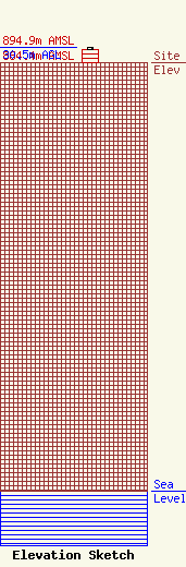
Site Elevation: 864.4 meters (2836 ft) |
| Height of Structure: 24.7 meters (81 feet) |
| Overall Height Above Ground: 30.5 meters (100 feet) |
| Overall Height Above Mean Sea Level: 894.9 meters (2936 feet) |
| Owner Info | Palomar Communications, Inc.
2230 Micro Pl.
Escondido, CA 92029
(760) 746-2120
palomarcomm@gmail.com |
| Contact Info | Palomar Communications, Inc.
2230 Micro Pl.
Escondido, CA 92029
(760) 746-2120
palomarcomm@gmail.com |
