|
|
Antenna Structure Registration 1031639 |
 |
Registration Info | Registration Number: 1031639 |
| File Number: A1246533 |
| FAA Study: 97-ACE-1438-OE |
| FAA Issue Date: 11/20/1997 |
| Status: Constructed |
| Date Constructed: 07/01/2001 |
| FAA EMI: N |
| NEPA: N |
Structure Info
| Structure Type: TOWER |
| Structure Coordinates: 37-14-2.0 N 98-39-56.0 W (NAD 83) |
| Structure Coordinates: 37-14-01.9 N 98-39-54.7 W (Converted to NAD 27) |
| Structure Address: 3 Mi Sw Of Corner Of Us 162 & Gyp Hill Rd |
| Structure City: Medicine Lodge, KS |
| Structure County: Barber County |
| Painting & Lighting Info |
FAA Circular #: 70/7460-1J |
| FAA Chapters: 4, 6, 13 |
| Remarks: STRUCTURE REACHED GREATEST HEIGHT 9/13/99 |
| Remarks: Removed expiration date from determination. Scenario 1./jjs/case#635066 |
| Remarks: STRUCTURE REACHED GREATEST HEIGHT 9/13/99 |
| Remarks: Removed expiration date from determination. Scenario 1./jjs/case#635066 |
| Elevation Info |
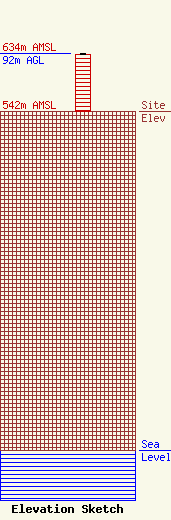
Site Elevation: 542 meters (1778 ft) |
| Height of Structure: 91 meters (299 feet) |
| Overall Height Above Ground: 92 meters (302 feet) |
| Overall Height Above Mean Sea Level: 634 meters (2080 feet) |
| Owner Info | FLORIDA PUBLIC RADIO INC
505 JOSEPHINE ST
TITUSVILLE, FL 32796
(321) 267-3000
WPIO@GATE.NET |
| Contact Info | Wilkinson Barker Knauer, LLP
1800 M Street, NW
Washington, DC 20036
Davina Sashkin
(202) 383-3428
dsashkin@wbklaw.com |
