|
|
Antenna Structure Registration 1042036 |
 |
Registration Info | Registration Number: 1042036 |
| File Number: A0843242 |
| FAA Study: 98-AGL-0895-OE |
| FAA Issue Date: 04/22/1998 |
| Status: Constructed |
| Date Constructed: 08/21/1994 |
| FAA EMI: N |
| NEPA: N |
Structure Info
| Structure Type: TOWER |
| Structure Coordinates: 44-1-19.0 N 103-15-37.0 W (NAD 83) |
| Structure Coordinates: 44-01-19.0 N 103-15-35.3 W (Converted to NAD 27) |
| Structure Address: 2425 Golden Eagle Dr |
| Structure City: Radid City, SD |
| Structure County: Pennington County |
| Painting & Lighting Info |
FAA Circular #: 70/7460-1H |
FAA Chapters: 3, 4, 5, 13 |
Remarks: OM&L TO REMAIN RED LIGHTS & PAINT. |
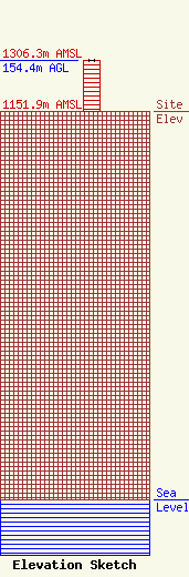
| Elevation Info |
Site Elevation: 1151.9 meters (3779 ft) |
| Height of Structure: 152.5 meters (500 feet) |
| Overall Height Above Ground: 154.4 meters (507 feet) |
| Overall Height Above Mean Sea Level: 1306.3 meters (4286 feet) |
| Owner Info | Haugo Broadcasting Inc
3601 Canyon Lake Drive Suite #1
Rapid City, SD 57702
(605) 343-0888
chaugo@haugobroadcasting.com |
| Contact Info | Haugo Broadcasting Inc
3601 Canyon Lake Drive Suite #1
Rapid City, SD 57702
Christian Haugo
(605) 343-0888
chaugo@haugobroadcasting.com |
