|
|
Antenna Structure Registration 1208887 |
 |
Registration Info | Registration Number: 1208887 |
| File Number: A0844453 |
| FAA Study: 2013-ANM-1529-OE |
| FAA Issue Date: 07/15/2013 |
| Status: Constructed |
| Date Constructed: 05/07/2000 |
| FAA EMI: N |
| NEPA: N |
Structure Info
| Structure Type: GTOWER |
| Structure Coordinates: 40-31-57.0 N 103-7-23.8 W (NAD 83) |
| Structure Coordinates: 40-31-57.0 N 103-07-22.0 W (Converted to NAD 27) |
| Structure Address: 1.5 Miles Northeast Of Old Akron Road And County Road 12 |
| Structure City: Sterling, CO |
| Structure County: Logan County |
| Painting & Lighting Info |
FAA Circular #: 70/7460-1K |
FAA Chapters: 4, 6, 12 |
Remarks: PRIOR STUDY 1999-ANM-1442-OE |
| Elevation Info |
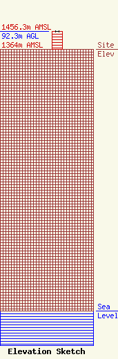
Site Elevation: 1364 meters (4475 ft) |
| Height of Structure: 91.5 meters (300 feet) |
| Overall Height Above Ground: 92.3 meters (303 feet) |
| Overall Height Above Mean Sea Level: 1456.3 meters (4778 feet) |
| Owner Info | NORTHEAST COLORADO BROADCASTING LLC
PO Box 472
917
FORT MORGAN, CO 80701
(970) 867-7271
alec@necolorado.com |
| Contact Info | NORTHEAST COLORADO BROADCASTING LLC
PO Box 472
917
FORT MORGAN, CO 80701
Alexander Creighton
(970) 867-7271
alec@necolorado.com |
